
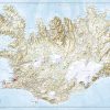
Central Canada Tourist map published by National Geographic. This map covers East Alberta, Saskatchewan, Manitoba, Northwest Territories, Nunavut, Ontario and a small part of Quebec. Roads and protected areas (national parks, reserves …) are indicated. Tourist attractions and photos also included. Cities index.
Detailed waterproof and tearing resistant.
Scale 1/2 100 000.
Related products
-47%

Binders & Binding Systems
Libreta transparente con anillas. Colección Primavera. Esperanza Buy Cheap Outlet
Original price was: $16.83.$9.00Current price is: $9.00.
-50%

Calendars, Planners & Personal O
Original price was: $19.90.$10.00Current price is: $10.00.
-46%

Office & School Supplies
Biblia Holman letra grande RVR60 – Café dúo tono – Cierre – Índice Sale How Much
Original price was: $38.88.$21.00Current price is: $21.00.
-46%

Book Covers & Book Accessories
Original price was: $14.77.$8.00Current price is: $8.00.