

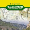
Hiking map of Tarryall Mountains & Kenosha Pass (Colorado) published by National Geographic. This map includes Pike National Forest, Lost Creek Wilderness, Pine, Bailey and Jefferson ; Kenosha, Bison, Stoney and Hankins passes ; Tarryall Reservoir ; the North Fork of South Platte and Wellington Lake ; a segment of the Colorado Trail. Scale 1:40,680. Trails, trailheads, points of interest, campgrounds are included. Waterproof and tear resistant.
Related products
-40%

New Collections
Biblia Holman manual letra gigante RVR60 – Caoba – Cierre – Índice Free Shipping Perfect
Original price was: $53.03.$32.00Current price is: $32.00.
-48%

New Collections
Original price was: $30.89.$16.00Current price is: $16.00.
-40%

Original price was: $53.73.$32.00Current price is: $32.00.
-58%

New Collections
Calendario 2025 – Ovejitas programador Outlet Low Shipping Fee
Original price was: $7.11.$3.00Current price is: $3.00.